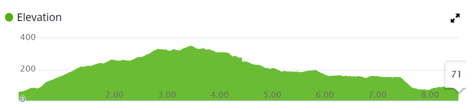
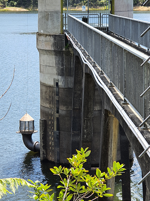
What a stunning 8.3km track! The Cossey-Massey Loop Track commences at the spectacular Hunua Falls, climbs and descends through mature native bush filled with bird-song and sidles next to Cossey Dam, one of Auckland’s precious water supply lakes.
The track is very well maintained and combines the feeling of a serious tramp with a local walking track – a great intermediate hike. The highest altitude of 353m ensures you get a great workout as you enjoy the beautiful surroundings. It is important to realise that there are plenty of stairs nearer the ends of both the tracks as well as one river crossing on the Cossey Track.
This walk combines two Hunua Tracks, the Cosseys Gorge Track and Massey Track into a fantastic 8.3km loop. The loop can be walked in either direction, both have a significant number of stairs to climb in the first part of the walk and therefore to descend as you get nearer the completion of the loop.
The walk commences from the main carpark at Hunua Falls, and after completing the Kauri dieback cleaning station, enjoy the views of the cascading falls from the bridge as you cross the river to start your walk. Turn left to complete the Cossey-Massey Track rather than the Falls Loop Track. Walk approximately 300m uphill until you reach the junction of the two tracks, take the Cossey Track to walk clockwise or commence the stairs on the Massey Track to walk anti-clockwise.
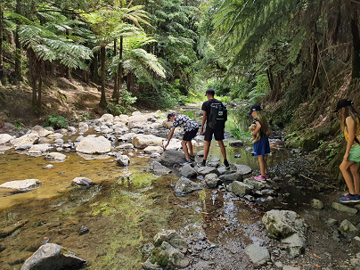
The clockwise route has an early river crossing and very steep stairs to ascend, while the anti-clockwise route has more flights of stairs but is not as steep.
Stream Crossing on the Massey Cossey Hunua Track
The track is in great shape, with a generally wide gravel path that winds its way through the thick and lush native bush. There are great views of the dam at various lookouts along the track and you get to walk across the front wall of the dam, a nice place to stop for a picnic, with toilets nearby.
Buggies and Wheelchairs
This track is not suitable for buggies or wheelchairs as it has many stairs!
We have added a Google Map to the 4.74km Mt Eden Circuit. This walk commences on Owens Rd. climbs to the summit and then across the new crater walkway before circumnavigating the mountain and enjoying the historic Mt Eden Shops.
The walk to the Clevedon Reserve lookout, known as the Stairway to Heaven, was suggested to us by some of my wife’s work colleagues and what a great surprise. Large kauri, Kahikatea, Puriri and Puka trees grace the slopes and make for an impressive bush canopy. Plenty of birdlife is enjoyed, as is the view across the Auckland City in the distance and the Hunua Ranges to the East. Adding to the value of this amazing walk is exploring the quaint Clevedon Village.
Beautiful spring sunshine, great friends, our dog and a simply wonderful track and environment. Today we enjoyed walking the long-version of the Puhinui Stream Forest Loop – great native bush, parklands of Totara Park and a picnic – the kids even had a swim in the stream, not really a swimming paradise but lots of fun!
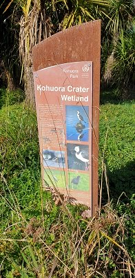
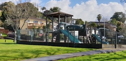
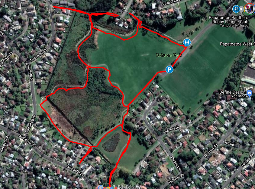
This is one of our smaller loop walks but a delightful one, boasting native bush and many birds. Kohuora Park is full of surprises – not only is it one of Auckland’s 50 volcanoes but is the home of the Papatoetoe Panthers Rugby League Club. The kids will also enjoy the playground.
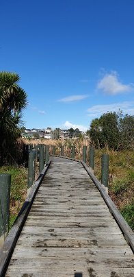
Enjoy the elevated boardwalk through the wetland
The volcano at Kohuora Park is about 600m across and defined by a tuff/rim that is about 30m high, some of which still remains today. The track is mostly flat and incorporates paved walkways and boardwalks.
Kohuora Park is one of Auckland’s hidden parks, probably one only known by locals and rugby league fans – it is the home ground of the Papatoetoe Panthers Rugby League Club. It is also one of Auckland’s 50 volcanoes, measuring about 600 meters across and 30m deep.
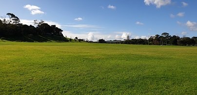
The tracks consist of primarily two large loops that thread their way between native bush and grass fields. The walkways are paved or boardwalk and mostly flat, with just some smaller undulations. There are marshlands that can in places overflow sections of the track in seasons where there is heavy rain – certainly, there were aspects of the track that were underwater when we completed it but it was still all passable. The local ducks were celebrating :).
Kohuroa Park Native Bush and Birds
We commenced our walk at the carpark closest to the tracks and walked clockwise. If you have the time, make the effort to complete the outer circuit, approximately about 2km – its a peaceful native bush walk, interrupted by plenty of wonderful birdlife – pukeko, kingfisher, white-faced herons and more waders. The northern part of the track contains a little undulation as it rises up some of the crater tuff.
The Tohuora Park can via the Papatoetoe Train Station, with just a few minutes walk.
Buggies/Wheelchairs
This walk is great for buggies and wheelchairs due to its relatively flat nature and paved walkway.
Dog Friendly
Kohuora Park is suitable for dogs and includes an off-leash dog area also. As with all Auckland Parks, dogs should not be on the sports fields.
One of Auckland’s less known and visited volcanic cones, Pigeon Mountain (Ōhuiarangi) is worth exploring. This is Auckland’s easternmost volcanic cone and offers fantastic views of the Hauraki Gulf and back across Auckland City. It provides a very unique perspective of Auckland’s geography and at only 55m in height is not a daunting climb.
Pigeon Mountain Ōhuiarangi fields and view towards the summit
One of East Auckland’s most scenic and popular walkways, the coastal Rotary Walkway in Pakuranga is a most do! It winds its way along the verge of the Tamaki River from Panmure Bridge, eventually finishing at Halfmoon Bay (via a few extra streets and paths).
The distance is 10.5km one way, so a significant walk if you are to do the return trip, but well worth it! There are plenty of options to complete portions of the walkway also and our Google Map will display all the possible entrances/exits along the Rotary Walkway. You will also find the Map will assist you greatly in navigating the Halfmoon Bay section of the walk.
Rotary Walkway: photo from Auckland City Council
This walk is suitable for bikes, buggies and wheelchairs, so great for any person/family, although at the halfmoon Bay end of the adventure there are a couple of flights of pretty steep stairs.
Walk Time
1 – 5 hours (10.5km one way)
Surface
Paved and Boardwalk
Difficulty
1 – 2 – the first 8.5km is mostly flat and on the Rotary Walkway. The final 2km has hills and stairs as it traverses through various streets and walkways to Halfmoon Bay.
Buggies/Wheelchairs
Excellent walkway for buggies & wheelchairs. The final 2km towards Halfmoon Bay will present some challenges, especially the stairs at the far end of Eclipse Place.
One of Auckland’s great walkways, this purpose built coastal path hugs the east-side of the Tamaki River from Panmure Bridge to Halfmoon Bay. The track winds its way in and out of pretty inlets, with boardwalks traversing through bush and mangroves. Enjoy the sea-breeze, water views, bird life and opportunities presented by the famous ‘snakes & ladders’ playground or some land-based fishing.
Paved Rotary walkway Track
There are many places you can commence this track and a lot of options for varying length walks. The Google Map clearly shows the various entrances to the path if you want to create your own loop walk. However, the complete 10.5km walk is full of highlights and worth the effort, even if it means completing it return for a 21km half marathon! The alternative is to drop a vehicle at each end of the walkway.
We have walked, run and biked this track on a many occasions – it is definitely a favourite. We normally commence at the Panmure Bridge end, especially as the first few kilometres contain so much variety, interest and beautiful coastal scenery.
Please note: Currently there are extensive roadworks around Panmure Bridge for the new busway and so parking by the bridge is closed. The best access will be via Kerswill Place or further along via Riverlea Ave.
Once strolling along the walkway, you will wind your way along the foreshore, mostly on paved undulating track. This paved track is interspersed with boardwalks that venture over the water and through the mangroves, at high tide you are walking just a little above the lapping water. The hills on this section of track are small but add interest to the first 2-3 km The middle section of the track is almost completely flat as it circumvents the coastline.
After passing your way around the second significant inlet, the impressive St Kentigern College campus will be on your right and you pass their rowing jetty on the left. The next significant landmark is the Farm Cover Reserve where you will find toilets and water. 150m past the reserve is the famous ‘Snakes & Ladders Playground’ – worth a visit even if you don’t have kids with you!
Farm Cove Snakes & Ladders Playground
Another significant inlet follows the playground as you wind your way towards Wakaranga Creek Reserve. This is another beautiful section with lovely houses, mangroves, pockets of bush and eventually opening to the green spaces of the Reserve.
A short detour from the Rotary Walkway takes you to the Prince Regent Playground, best known for its long tube slide. Another 250m – 300m through Pigeon Mountain Wetlands and you can visit Pigeon Mountain for a spectacular view of the local area and Auckland isthmus!
Pass through Wakaaranga Creek Reserve and take the western exit to Curacao Place. The trek now leaves the Rotary Walkway and traverses a series of quiet streets and walkways across the clifftop of the Halfmoon Bay suburb. Enjoy the varied views across the city and Waitemata Harbour, as well as many beautiful homes. This approximately 2km section takes you to the Halfmoon Bay marina, shopping centre and wharf. Enjoy a refreshing ice cream at Delishimo. There are also a range of restaurants at Halfmoon Bay if you want to stop for lunch before starting a return journey!
The track across the last 2km to Halfmoon Bay has a lot of variety. Once completing the various streets, a flight of stairs takes you back to a track that hugs the coastline and clifftop. There are stairs heading down form the end of Clyside Ave, with a semi-accessible small beach just off the track. Another set of stairs climbs back up to the clifftop track – continue along here until you reach the stairs down to Halfmoon Bay.
You are here! Enjoy the ice cream, restaurants and other services. This is also where you catch the ferry to Auckland City or Waiheke Island.
Hamlins Hill (Mutukaroa) Regional Park is a gem in the midst of Auckland City with a rich history and plenty of open space for you to unwind and enjoy. You can enjoy 360 degree views of Auckland city and explore the bush where you almost forget you are in the middle of New Zealand’s largest city. At times you are only 20m from the main Eastern Arterial route, but you feel one hundred miles away!
Amazing Hamlins Hill – serenity in the heart of Auckland
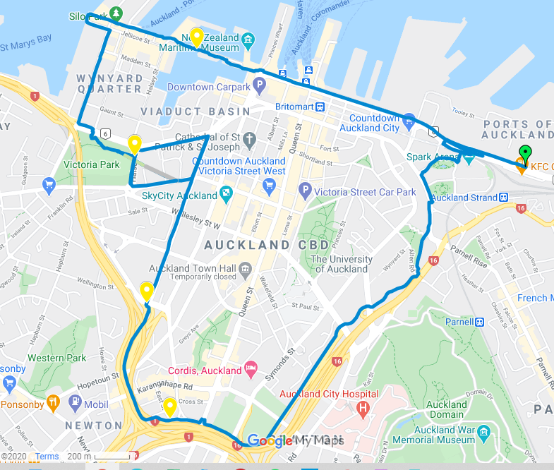
Enjoy a circular 8.5km central Auckland walk that takes in some of our cities great sites, including the historic Downtown Ferry Building, buzzing Wynyard Quarter, Victoria Park, eye-catching Pink Pathway and Auckland University. This adventure provides stunning views across Auckland, plenty of opportunities for cafe’s & ice creams and essentially circumnavigates the central city.
The iconic Auckland Pink Pathway for walking and biking
We completed the route by starting by the Spark Indoor Arena (as more parking opportunities) and venturing in an anti-clockwise direction. Catching a bus or train to Britomart and walking to the Ferry Terminal and commencing from there would make a great starting point if you were making use of public transport.
We commenced our walk by the Spark Arena due to better parking but quickly made our way past the historic Auckland Ferry Terminal as we enjoyed the views of Auckland’s waterfront and harbour.
This is always a busy and bustling part of town as people come and go from the Britomart Bus & Train Terminal and Auckland’s Ferries.
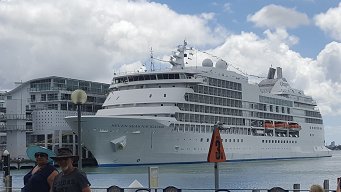
At the Ferry Terminal are a range of cafe’s and restaurants, including the Island Gilato ice cream cafe. If you want to make a whole day of it, perhaps take a trip to Devonport also on a Fullers ferry. As you pass the wharf, maybe there will be a cruise ship to admire or just enjoy the sparkling Waitemata Harbour.
Continue your journey heading to Wynyard Quarter, including a view of the historic vehicle lighter-basin draw-bridge before crossing the newer pedestrian draw-bridge. Take in the views of the large launches and yachts moored at the wharves. Wynyard Quarter and Tank Farm have been extensively redeveloped over the past few years and often have a variety of interesting entertainment and feature events.
Next, head to ‘greener pastures’ as you leave the Wynyard Quarter via Beaumont St and enjoy the open spaces of Victoria Park, home of Grafton Cricket Club. There are also toilets and water, as well as playgrounds and a skate park. Enjoy the many beautiful large trees that inhabit this Downtown Auckland park. You may also want to take a small detour to Victoria Park Market, the most famous of Auckland’s markets.
Its now time to start your ascent which will eventually get you to the famous Pink Pathway. You have a choice of walking via Fanshawe St or Victoria St, both options include a steep climb and arrive on Nelson St, just a block away from the Sky Tower. This part of the walk includes plenty of road crossing and traffic lights but is safe and easy to navigate.
At the top of Nelson St, you are greeted with the entrance to Aucklands Pink Pathway, constructed to efficiently join the west side of the city center with the eastern side over the top of Auckland’s busy motorway spaghetti junction. It enables direct access to Grafton Gully and Auckland University, while also joining the Western bikeway. The Pink Pathway is well illuminated at night, making it a safe option even in the dark. Experience the hum of the city as you walk on top of the motorway and the views from the transparent sides.
Grafton Walkway
Signage in Grafton Gully
As you leave the pink walkway, you head to Upper Queen St and follow the signs to the Grafton Gully bike-path/walkway. Follow this path downhill all the way back towards the bottom of Parnell. On your left is Auckland University and on your right is the Auckland Domain, Its a beautiful walkway and all the better enjoying it heading downwards! Once you return to near sea level, the path cuts through the base of Constitution Hill and along Beach Rd until making your way back to the Spark Arena or Ferry Terminal.
Buggies and Wheelchairs
The walk is suitable for buggies and wheelchairs. Just be prepared for some effort pushing them up Victoria and Nelson Streets,
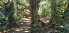
This walk is through an extensive site of native bush alongside Totara Park & the Manurewa Botanical Gardens is beautiful, challenging and interesting. The most common access for this loop track is from Everglade Rd, which has plenty of parking. An interesting aspect of this walkway is a large flight of stairs at the turn-around point of the loop. The northern side of the track has a number of steeper sections and more stairs. The southern side of the track is largely flat and follows the Puhinui Stream. Continue reading Puhinui Stream Forrest Walk→
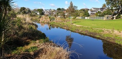
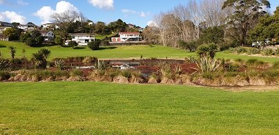
This stunning walk surprised as we set out to discover an original walkway today. Off the beaten track – quiet and peaceful, a wonderful easy stroll of about 4.6km (return) from Whitford Beach alongside the Turanga Creek estuary. Beautiful water views, huge trees, green pastures and majestic houses grace this walkway.
This track is accessed from the end of Clifton Rd from Whitford Beach.
Long Bay Regional Park is situated on the northeast coast of Auckland and is one of the cities most popular recreation destinations. The long sandy beach, extensive park facilities and range of walking tracks make it a great place to walk. Enjoy the open fields or native bush. Be refreshed by the ocean air and the stunning views of the Hauraki Gulf and its many islands.
Northern end of Long Bay Beach
Parking is plentiful at Long Bay and there are toilets, water fountains, children’s playground and BBQ’s within the park area behind the beach. Take in some history with the Vaughan Homestead or a walk to the military pillbox.
Long Bay Regional Park offers explorers a range of walks from 15 – 20 minutes up to 3 – 4 hours, all of which are highly rated. There is more detail on each of the walks provided below, but here is a brief overview:
Nature Walk: this is a short loop walk through native bush of about 15 – 20 minutes.
Granny’s Bay Walk: this loop takes you through the wetlands and bush to the ridge, detour to the pillbox and then to Granny’s Bay. Return via the rocks if the tide is low enough. Time approx 45 – 60 minutes.
100 Acre Walk: add this detour to the Granny’s Bay walk and enjoy a kilometre walk through the regenerating native bush. Time is approx 15 mins from the Granny’s Bay walk.
Okura River Walk: this is a good half-day trek and extends beyond Granny’s Bay to the Okura River mouth. At lower tides, you can return along the rocks and beaches.
Select from short walks of just 15-20 minutes up to a full half-day adventure. Enjoy the sea, the views, the bush and birdlife – Long Bay is simply a wonderful place to explore and enjoy.
Vaughan Homestead
The Vaughan Homestead is worth a detour and is a little beyond the entry to the main track. This historic home is situated at the northern end of the beach. More historic information can be found here.
Nature Walk: 15 – 20 minutes, 1.1km
This short walk is a loop that commences from the end carpark of the Long Bay and takes in the Wetland and Nature Trail tracks. Once at the far carpark, walk northwards through the chain across the driveway. About 100m from the start, turn left at the coastal track sign and head into the flat wetland area. Follow the pathway for a further 300m until you reach the bridge where you will cross the stream that heads to Long Bay Beach. Keep a lookout for a variety of swamp birds.
Track to Nature Trail
Head across the bridge and up the hill. 100m on the right is the Nature Trail which follows the stream for about 250m before existing just below the historic Vaughan Homestead. The Nature Trail tracks through attractive NZ native bush. Turn left to view the Vaughan Homestead or right to head back to the start.
Granny’s Bay Walk: 45 – 60 minutes, 3.8km
Beautiful Grannys Bay
This is the most popular walk at Long Bay Reserve as it provides stunning views across the Hauraki Gulf and access to the less busy and beautiful Granny’s Bay.
View to Rangitoto Island
Take the same route as described above for the Nature Trail, however, continue to climb the hill track until you reach grass fields. Once at the top of the hill, walk through the grasslands towards the clifftop. This is where you get your best views across the water and all the way to Auckland.
Gun Emplacement Detour
A small detour on a bush track, through the fence line, near the cliff takes you to a historic pillbox. There are glimpses of views back down Long Bay Beach from here. The track at times is closed due to slips, so be mindful of its condition.
At the fence, take a left and continue to follow the track down the hill to the Beach. At high tide, it is a beautiful swimming beach and very private. As the tide recedes, it becomes part of the ongoing coastline and not so attractive for swimming.
There is a second Bay over the next hill that is also pretty but be aware that clothing is optional here and so most may not want to stop here for the swim and picnic!
Return to Long Bay via the coast
The return to Long Bay can be achieved by walking around the rocks if half-tide or lower, or by retracing your steps up and over the hill. Take care though as it can be slippery when wet.
100 Acre Walk: 15 – 20 minutes, 1.6km
100 Acre Tea Tree
Enjoy a tranquil stroll through native bush on the 100 Acre Track. This is a regenerated area of native bush and enjoys great birdlife. The track is wide and grassy, a little muddy in the wet. The flowering Tea Tree and birdsong are highlights.
Track through 100 Acre
Access the 100 Acre track from the walkway to Granny’s Bay or from directly adjacent to Granny’s Bay.
Okura River Walk: 2.5 – 4 hours, 9km
Make a day of your time at Long Bay Reserve and complete the Okura River Walk. This is pleasant and spectacular. The track these days is pretty good, although still has some muddy patches in the wet towards Okura River.
This walkway can be completed as an out and back walk or using the track one way and the coast the other. The coastal return should only be attempted when it can be completed within 2 hours of low tide for the entire trip. It can also be very rocky and slippery but is a great option for more confident walkers. I have completed this one many times when it was a route I ran a lot and it is amazing but requires care.
Take the track to Grannys Bay and then continue over the next hill to Pohutukawa Bay. The track then climbs again upwards adjacent to farmland on the left and clifftop bush on the right. The walk is grassy and undulating, with views along the way. As you get closer to the Okura River Mouth, the track heads more westerly until you drop to the Okura River.
If the tide is low enter the ‘beach’ and then turn right to return via the coast to Long Bay. If the tide is not low, retrace your steps to return to Long Bay.
Buggies and Wheelchairs
Many of the Long Bay tracks can be accessed by buggies and wheelchairs. The constraint is more the hills as some are steep.
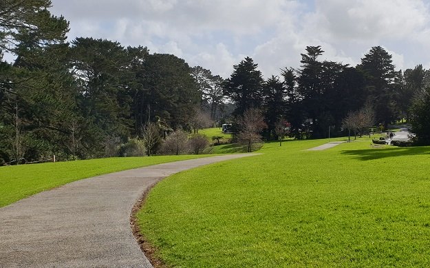
The Unsworth Heights to Rosedale Park walkway is a spectacular ‘there & back’ walk with many activities and options for variety to make it a loop. Enjoy native bush, streams, playgrounds, fields and even frisbee golf! The core tracks are paved and wide with some more adventurous options of natural bush tracks if desired. It really is a walk (or bike) for the whole family.
As we enter the second half of our Covid-19 lockdown in New Zealand, we thought it might be a great idea to put together a list of some creative ideas you could try while walking! Of course, all this must be completed locally, in your bubble, with 2m physical distancing and not touching objects such as park benches.
Here are 7 ideas we thought you could try with your Bubble!
1. GPS Walking Pictures
My sister sent me a Facebook post of a guy in the Hibiscus Coast who took to making pictures as he walked using his GPS and running app Strava.
You can use your GPS enabled sports watch or an App on your phone such as Google Maps or MapMyRun.
Scavenger Hunt
Construct a list of items you and your bubble must find and ‘collect’ on your walk. This can include physical collection that you can put in a bag or a photo collection using your phone to record your ‘find’.
A sample list of ideas could include:
Collect a leaf
Take a photo of a house with at least 3 teddy bears in the window
Collect a piece of rubbish
Find and photograph a red car in your neighbourhood.
Find and photograph a bird
Find signs around your neighbourhood that start with every letter of the alphabet
Collect a seed, nut or cone or similar that has fallen from a tree
Photo of a road sign
Collect a random object like a discarded ball, sock, pen, tin or similar – anything random that should not normally be just lying around on the footpath, park or roadside
Photo of a rubbish bin
Photo of a power transformer or phone exchange box
Photo of a sign in your area related to Covid-19 eg. Playground closed due to Covid-19 etc
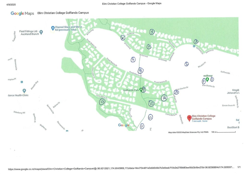
Orienteering Locally
Orienteering is a fantastic family event and while its not quite the same around your local streets, it can still be accomplished. Your unique ‘Bubble’ orienteering can be organised as follows:
Number various stations on your map where you feel you can place a marker.
Prepare a list of clues for each station that provides participants with a little more information about where the Station is located. You can choose to mix up the numbers for various participants, so they are not simply following each other eg. One list goes numbers 1 to 15, the other list is numbered 15 to 1. An example of our sheet can be found here.
Determine what you will use to identify your stations – small flags, cones, stones, wood, tin cans or other things you can find. Try to make them a little bright if possible and then add the ‘Station Number’ and a ‘random 2-digit number’ to each marker. The participant must write the random number on the form for the correct Station as evidence they located the correct point.
Take a walk and set-up the course, dropping your station markers at each location.
Give the participants their Map, Station List and Pencil. This could be done as individuals or pairs/groups depending on the ages of the participants.
Explain the orienteering rules and reiterate the Covid-19 lockdown walking rules and send them on their way.
Pick up your phone, camera or ipad and head outdoors for your walk and focus on recording your lockdown walking experience in pictures. You will be amazed at the extra things you notice in your neighbourhood as you look more closely.
Perhaps you can then produce a presentation using your favourite photo or presentation app/software.
Add Exercises into your Walk
During your walk, simply add in a range of exercises to complete. This provides variety and extra health benefits. Some exercises can include:
Take a sheet of paper (or record on your phone) to spot and record as many types of trees and birds as you can find in your area.
The NZbirds website https://nzbirdsonline.org.nz/ has superb tools to assist in identifying birds found in NZ. This can easily be done using your phone while walking.
Trees and plants are much harder as the variety is almost endless. For native trees, try DOC or Terrain.net.nz
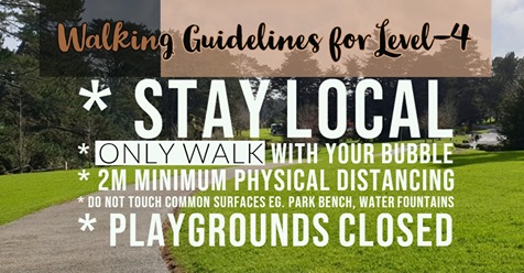
The Government provided further clarification regarding outdoor activities and walking under Level-4 Lockdown.
The government reiterated the importance of people adhering to Level-4 Lockdown to ensure the maximum effectiveness is achieved. They confirmed once again that people can walk (and bike) locally to assist with peoples physical and mental health, reiterating the importance of walking in your bubble and maintaining 2m physical distancing.
Activities now specifically prohibited in Level-4 are boating, fishing, hunting, surfing and other water sports and tramping. The emphasis seems to be the prevention of accidents and rescue which will take resources away from other areas of important need.
As a walking community, we need to be aware that tramping is not lawful under Level-4. It is important that when we are out walking, ensure it stays as a local walk that has minimal risk with no need for rescue if someone should injure themselves – maybe sprain an ankle or similar.
It is important to consider if any bushwalks you are engaging in meet the new criteria. For example, some bushwalks can have wide pathways similar to a dirt road, while others are narrow, steeper and uneven.
Walking in Level-4
Walking Loop Tracks only?
One of our walking community wrote in a comment to the walksinauckland website that “we should encourage circular walks, rather than out and back so we do not have contact points at narrow parts in the walkway, bridges etc.”. Liz went on to suggest we could place arrows that ensure people follow a certain direction when walking.
This seems to be a great idea and perhaps one we should try and get some momentum. Maybe we could try using chalk on some of our walks to encourage people to walk in one direction.
Any other ideas on this?
Self guided short circular walks in Auckland for health, fitness and fun


